Monday 2 May 2011

Big Brook-VS-Footbridge

Precision CNC's operate utilizing water to cut tiny machine parts so is it any wonder that our nice new 28' footbridge took a trip downstream during the last rainstorm?

Pittsburg, as well as much of New England, got a lot more rain than it needed, the temperatures rose, and a combination of the two brought flash floods down from the mountains, diluting the tributaries and flooding the Connecticut River Valley. Big Brook is one of those 'tributaries'.


So now we can figure in another 'work party' (yee ha!) to drag the planking out of the alders and set the metal truss back into place using a winch, blood, sweat & tears. If this sounds like your kind of fun, just let us know and we'll sign you right up!

And seeing this is the second time in less than a year that we've received 100 year rains, perhaps we should raise our side supports a couple of feet?

Tuesday 19 April 2011

Gentlemen...Start your Engines!

Crank up those chainsaws, it's going to be a busy year!  Relentless winds have played havoc as usual.  This is the beginning of the border trail - rightly named because it runs between this place and our neighbors, sometimes crossing the lines.


Just in this short section there are two trees down.  Another tree snapped right beside Big Rock Lean-to and fell over the top, never touching the roof - whew!


Monday 11 April 2011

Pondicherry Wildlife Refuge Directions To Trailhead

We are planning to have a Trail Work Day at Pondicherry NWR on Sunday 17 April 2011. We will meet at the Trailhead on Airport Road near the Biomass Power Plant at 0900.

Travel to Lancaster. Turn east onto Route 2 and follow Route 2 to
Jefferson. Turn right onto Route 115A and take it all the way to the end
at Route 115. Turn right. Travel three or four miles to Airport Road on
the right (airplane logo). Travel downhill a mile until just before the
PSNH chip-fired power plant. Look for a narrow lane on the right. Turn
right and enter a parking lot in five seconds. This is the main parking
area for Pondicherry Wildlife Refuge.

If you are late then just meet us on the Little Cherry Pond Trail which starts 1.7 miles from the trailhead.
Pick up the trail (old railbed) beyond the sign kiosk. Walk 1.2 miles
staying straight through Waumbek Junction until you reach the awesome
viewpoint across Cherry Pond.
Beyond the view point along the tracks come to a plank crossing which
marks a trail junction.
On the left is the Little Cherry Pond Trail. To the right is the Ice
Push Ramparts Trail (CT) which heads north along the marshes to the Col.
Whipple Trail (CT) after 2,000 feet.
The work agenda is for work on Little Cherry Pond Trail

Work Weekend Scheduled in the Nash Stream Forest

Join T.C.T.A. for a work weekend scheduled in the Nash Stream Forest for June 4-5, 2011

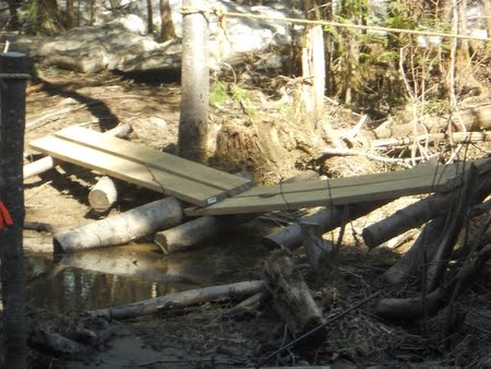
The Rowells Brook Bridge HAS to be rebuilt. Nothing is more important
than that.

If there are enough people, we'll break out into two crews to do
different things.
If you're interested, please email ahead at cohos@cohostrail.org to let us know you're coming, which days or both, and whether you're staying overnight at Kamp Kirk.  Send emails to the attention of Kim Nilsen, subject:  Nash Stream Project.

Things to bring: x-tra socks and boots, water, snacks, warm clothing, gloves, & hat.  If you're staying overnight Saturday accomodations are free, just bring a sleeping bag & pillow.  Tools needed for the job: 1 average chainsaw with gas and oil, 1 log shave (I have one), 1 ax, 3
or 4 good hammers, 2 wrecking bars with claw & 1 shovel - lopers and a bow saw if you have them. 

The Project in Detail:
Improving the Rowell Brook bridge (two miles from the Christine Lake Road in the south
eastern quadrant of the Nash Stream Forest).
The project should take an average work day, including walking in and walking out, depending if
we have no less than three people on hand. It would be great if we could attract five or six folks
to assist.

There are two parts to the project. The downstream log stringer absolutely has to be replaced.
But since we would have to pry up the deck on the bridge to remove the stringer, we might as
well replace both stringers while we are at it. That means that two modest-sized trees have to be
taken down, limbed, cut to length, peeled of their bark, and moved into position. The foundation
support cross timbers probably will have to be replaced on each end. We’ll do that, too.

The second part of the project is disassembling the bridge carefully and then reassembling it
once we have the new stringers in place.

Trail Work Day Scheduled for the Pondicherry Wildlife Refuge

Note:  Directions to the trailhead and more information on the form you need to sign ahead of time will be coming as soon as I get the information - Lainie


The following note came in from Pondicherry Wildlife Refuge manager David
Govatski regarding a trail work day in the refuge:


We are planning to have a Trail Work Day at Pondicherry NWR on Sunday 17
April 2011. We will meet at the Trailhead on Airport Road near the
Biomass Power Plant at 0900. If you are late then just meet us on the
Little Cherry Pond Trail which starts 1.7 miles from the trailhead. We
have over 60 blowdowns to clear passage through. The goal is to open the
trail for walking. We will probably not be able to make it look perfect
because we still have snow and ice on the trail and some branches will
be frozen in. We can get that final work later when it thaws out.

I will have a chain saw. If you have a bow saw bring one along and also
some loppers. I expect we will still have some snow so have footwear
appropriate for wet conditions. Gloves, eye protection and work clothes,
lunch and water, camera and binoculars. We will be finishing up by
mid-afternoon.

We need to have you fill out the attached volunteer form and scan to send
it back to Barry Parrish (See Trailing Message). You can scan the form
with your signature and email it or you can put in the mail. This will
cover you in the event you get an injury. This form will be good for the
entire year so even if you are not helping on Sunday but plan to work on
trails next month go ahead and fill it out.

Saturday 9 April 2011

Snow still piled high in the North Country!

Took a ride up to 2nd Connecticut Lake to see if any of the trailhead signs were visable.  This is the trailhead to Idlewilde Spur...in between the snowmobile trailer and the car...


I think it'll be awhile before that melts down! 

Less snow at the Magalloway Road but the sleds were out in full force...


Warm weather predicted for the whole week!  50's today...shed hunting is getting underway!

Monday 4 April 2011

Moose Kill - Game Cam Photos

Not sure how my batteries were holding up through our 8" snowstorm, I just had to see what was on my game cam down at the moose carcass.  I pushed the on/off button for the photo display and saw that 63 photos were on there.  I couldn't get home fast enough!

The first 30 - 40 photos were slight variations of this one here:


Yup, crows!  The next 15-20 were branches moving from the wind and a fox...


But the last few were coyotes...


Saturday 2 April 2011

Our Incredible Journey

My fourth grown daughter, Lisa, inherited chronic trailblazing sickness as a child and left southern Maine in August 2010 to help ‘build The Cohos Trail’ in Grand Coos County - The Great North Woods of New Hampshire.

We spent three strenuous days cutting new trail, blazing, raking & signing then stood back, admiring our newly planted cedar post sign and made the statement… ‘Now alls we have to do is GPS the thing and we’re done with it!’

The next morning we were back at the signpost with GPS in hand, ready to trek almost due east a mere 1.5 mile, then turn around and retrace our steps… A pretty simple day ahead compared to the previous three, we thought.

We leisurely started out on our journey being careful to mark a waypoint where the trail angled a bit and, oh ya, we can’t forget to mark the stream crossings and certain points of interest, now can we? Lisa was taking critical waypoints and I was marking down on paper things to remember. We wrapped up the project mid-afternoon and called it a day. I could hardly wait to plug the waypoints into the computer when we got home to see how far we had gone with this trail!

What I saw dumbfounded me! We had actually started the trail just 'ouest' of the Chartierville Junction of 257 Nord and 212 ouest in Quebec Canada, passed through customs without passports and evidently no one saw us…headed south, swimming across Lake Francis - trudged through Nash Bog in the Nash Stream Forest - sloshed thru the wetlands between Page Hill and Tug Mountain outside of Lancaster, straight through the Mt. Washington Regional Airport - skipped the conventional trails like Liberty Spring Trail orThe Falling Waters Trail and just plunged through the valley between Lafayette-Lincoln-Little Haystack and Owl’s Head through the White Mountain Nat’l Forest - swam across Newfound Lake just west of Lake Winnipesaukee, down through Keene NH and into Massachusettes, just missing the Quabbin Reservoir, Phew!

From there we took a quick jaunt through Connecticut and crossed Long Island Sound just east of New Haven… came ashore near Flanders and exited land again by Fire Island… kept on swimming the Atlantic Ocean until we’d obviously had enough and turned around approximately 90+ miles east of the North Carolina coast - Shackelford Banks, just south of Pamlico Sound, to be exact.

Our return trip was pretty much the same route with slight variation - Seems like if we swam a lake going down, we swam it going back, never learning a dog-gone thing! We made it back to Chartierville by mid-afternoon and somehow got back thru US Customs (Ya Right!) to our original little spot on Round Pond Road all in a mere day - How’s that Team Granite?  So don't bother emailing cohos@cohostrail.org looking for GPS Coordinates for the Round Pond Brook Trail 'cause there ain't none!


Friday 1 April 2011

Moose Kill

I took a walk yesterday and on the way home I cut across the field in back of Ed & Melissa's camp and took the old trail through to the upper camp road ...
...not long after I left the field and entered the woods, something off to the right, down over the embankment caught my eye - 'Hey - That looks like a dead moose down there!'..... I left the trail and walked down to the carcass when it occured to me that this was a fresh kill and I was in unfriendly territory, unarmed!


I hoofed it back to the house via the trail from Dean & Heidi's camp and found tracks and evidence that the attack had begun at least a tenth of a mile from where the moose had collapsed.
Back into the house I started assembling equipment for lifting tracks, taking photos of the area and collecting feces samples... grabbed my .38 special for safety measures and headed back out.
I set my frame around the clearest track then poured out my plaster-of-paris concoction -left that to set up and went down to the kill zone.

After several photos from all different angles, I spread the search out to determine what and how many were involved in this kill. The large set of tracks came down off from the mountain but smaller tracks wove out through the thick spruces nearby. Other than the tell-tale turkey tracks, all were clearly canine!

I retraced my steps back to the carcass and was amazed to see that one of my prior boot tracks had filled up with a pool of blood indicating that this was an extremely fresh kill, maybe that morning.
I rigged up my game cam on a tree 4-5 feet from the carcass dummying it up with sticks for props so that the infrared light would be on the carcass and not up into the Milky Way - collected some feces into a sterilized jar - then went back to the track mold which had set pretty much by this time.

Now I have to wait a few days before checking the game cam and finding out what killed the bull moose...

Note: I had never done a snow mold before and wasn't sure whether it would work or not - about the only real difference is I added more plaster-of-paris to make the paste thicker. Even though mine didn't fall apart, I had a lot of plaster on my hands from where 30 minutes just wasn't long enough to set for the wet and 35 degree conditions...It finished drying in the house and has joined my moose, fisher and raccoon track collection.

Monday 21 March 2011

Northern New Hampshire as a Fabulous Destination Spot

In August, 2010, Pittsburg, New Hampshire had the honor of Untamed New England Adventure Racing Team members canoing, kayaking, biking, hiking, orienteering, and showing their stuff with Eastern Mountain Sports on the ropes at Garfield Falls.  These teams donated their time on three conservation projects involving The Camp Otter Trail (a section of The Cohos Trail), The Washburn Family Forest, and a project at Little Hellgate Falls for the NH Trails Bureau and State Parks, DRED

Adventure Racing will be returning to Pittsburg New Hampshire in the spring of 2012!

Shed Hunting is picking up momentum as the snow packs start to disappear exposing some pretty nice sheds.  MtnGoat hasn't been out yet this year but will do a guided stint with a couple from Connecticut after the snow is gone. 

Geocaching The Cohos Trail and attractions in and around Pittsburg NH is always a popular sport for the whole family to enjoy and I heard that there may be another geoparty at Lake Francis State Campground this year (2011)???  Anyone know???  The Cohos Trail is jumping in on the fun and will host 20 new caches!

The Hiking Trail sections of The Cohos Trail will open for hiking as soon as the snow is gone and some of the trails have been used heavily for snowshoing and X-country skiing this winter.  The Falls in The River Trail which runs from the 2nd Connecticut Lake Dam to mile marker 232.0 on US RT. 3 seems to be the most popular trail with 'lunch rocks' on the Connecticut River for viewing the flume-like falls.  Another notable trail is the Moose Alley Trail which is the southern connector for the Falls in The River Trail.  The Moose Alley Trail runs from mile marker 232.0 on US RT. 3 to The Magalloway Road.   Snowshoeing back out to Rt. 3 once you hit the Magalloway Road would require 1.1 miles additional unless you hooked a ride with a snowmobiler.  

Right now, the tower on Magalloway Mountain and Garfield Falls are snowmobile/snowshoe accessible only (unless you're a moose) - I heard the snowpack going up Magalloway Mtn. is still quite thick and the boulders aren't too exposed yet.

The trail going into Indian Stream Canyon is accessible via snowmobile/snowshoe but must be roaring right now with the snow melt last week.  I don't think I'd try to cross the stream at any point but it must be awesome to see from the bench on the eastern ridge that NHState Parks & the Trails Bureau set up!

Little Hellgate Falls is off from Snowmobile Trail 137, right there near the junction of trail 20.  From the junction of 137/20 take 137 to the second bridge, take a left and snowshoe in.  A nice job was done on this trail by the State and one of the scenes of the above-mentioned Adventure Race.

Fishing is popular on The Connecticut River and also on the Lakes and Ponds.  Check Tall Timbers site also for more information.

Name your favorite summertime activity in Pittsburg!  Add your comments!   


Friday 18 March 2011

New Trail Sections in Pittsburg, New Hampshire

New trails opened up in Pittsburg in the fall of 2009 and the summer of 2010 ~ From the Idlewilde Road all the way to the Camp Otter Road, it's No More Road Walking!  Yeah!!!!  From Deer Mountain Campground there's a trail called the Black Cat Trail that should be approved this spring but for the timebeing you'll either have to follow the flagging through the woods (good luck!) or walk Route 3 south approximately 4.4 miles to the Idlewilde Road on your left.  Walk a few hundred feet on the Idlewilde Road and take a right at the trailhead to Idlewilde Spur.  This short .3 mile section brings you out to the 2nd Connecticut Lake Dam where you can enjoy the bench on the point, do a bit of fishing, or take a quick dip before heading south across the parking area to the trailhead of The Falls in The River Trail. 

The Falls in The River Trail pretty much follows within sight of the Connecticut River for most of the way with several spurs to the river for those carrying their fly rods.  Cross the Dry Brook area on new bog-bridging and the trail takes you to the flume-like falls in approximately 1.5 miles from the dam. 

Continue south after enjoying the lunch rocks for half a mile crossing the new 28' footbridge over Big Brook.  At the next junction, you can either bail out at mile marker 232.0 on Route 3 (right turn on trail) or take a left onto The Moose Alley Trail.

The Moose Alley Trail runs approximately 1.6 miles to the Magalloway Road where you'll cross the road onto the Camp Otter Trail. 

The Camp Otter Trail was the scene of the fabulous Untamed New England Adventure Racing Conservation Project where each of the teams helped to build 400 plus feet of bog-bridging over one of the soggiest, boggiest areas on the trail.  The bog-bridge topped out at over 800 feet when complete.  I wonder if that's any kind of a record?

Shortly after stepping off the last log of that span, the trail takes a sharp left staying in the woods before breaking out onto a grassy abandoned skidder road.  The trail turns into a narrower path and eventually dumps out onto the Camp Otter Road.  Take a right and bear right at all junctions, coming back out onto Route 3. 

Turn left and follow Rt. 3 to the River Road.

Wednesday 23 February 2011

Welcome!

Welcome to our Trail Blog as we seek to promote the Cohos Trail in the North Country of New Hampshire, Coos County in fact!  We're a long-distance hiking trail (162+miles) with multiple day hikes available, which will be covered in this blog.  We hope you Join us on Facebook & Twitter!